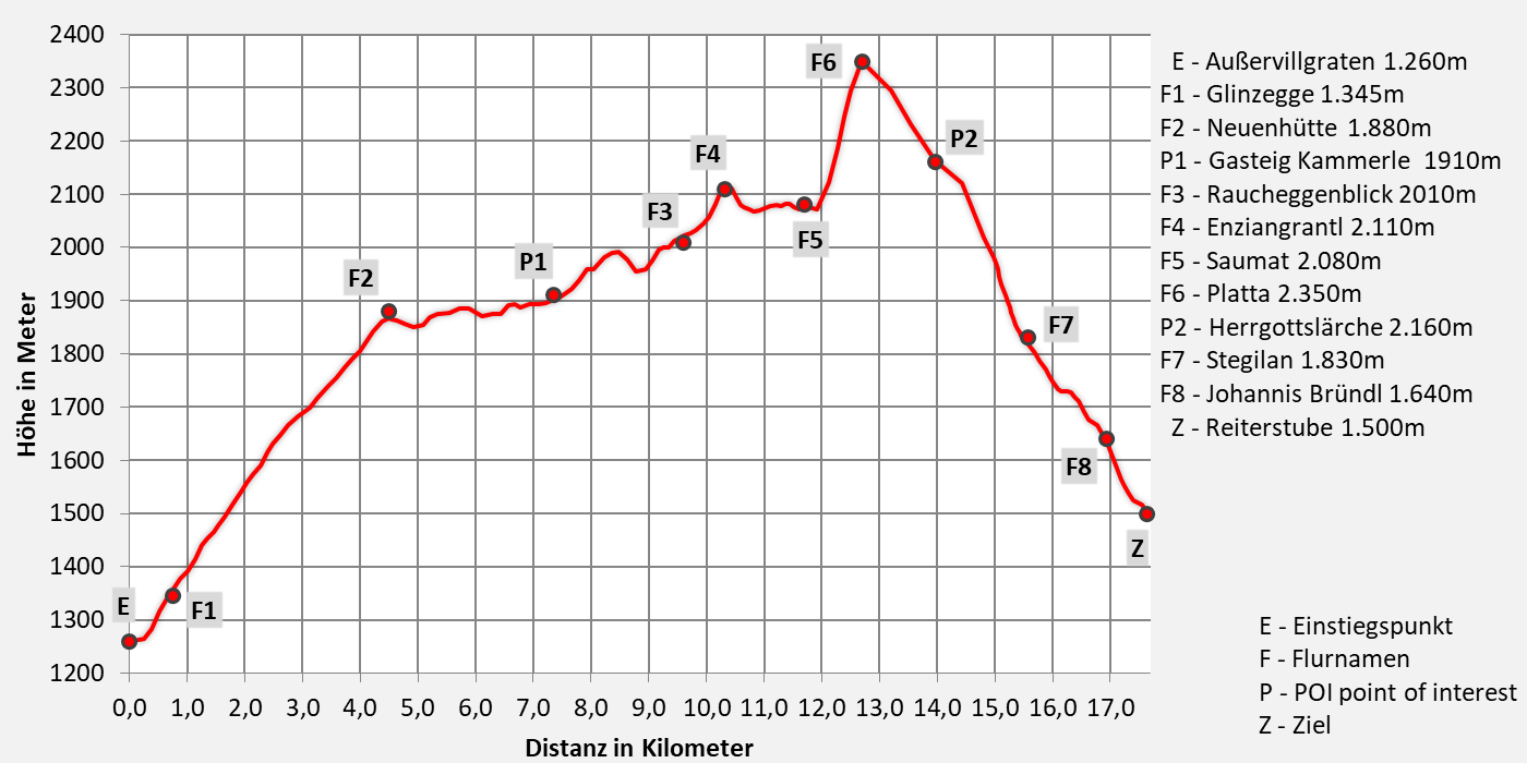
 Stage 1: Almenweg to Herrgottslärche
From Ausservillgraten to the Reiterstube
Walking time 8 hours - moderate hiking
- 17,7km walking distance
- 1260 ascent altitude
- 1030 descent altitude
- lowest point: 1.260m - Außervillgraten (Start)
- highest point: 2.350m - Turn to Sommerwand-Köpfl
Over 9 alpine pastures to lofty heights
We make it like the great role models of the first ascents and inventors of the Her-Ass Villgratental and climb up the mountain from the village of Ausservillgraten to the ridges of the Tessenberger Alm. The path leads through the battle zone of the high alpine vegetation, past dark spruce and light larch forests, Alpine rose meadows over nine pastures into the Winkeltal. The route connects four mountain peaks with a limitless view over the garden of the giants of East Tyrol, far to Carinthia to Lake Weissensee and into Styria. Below us, the sparsely populated Winkeltal winds up to Volkzein, our hiking destination on the second stage.
Directions
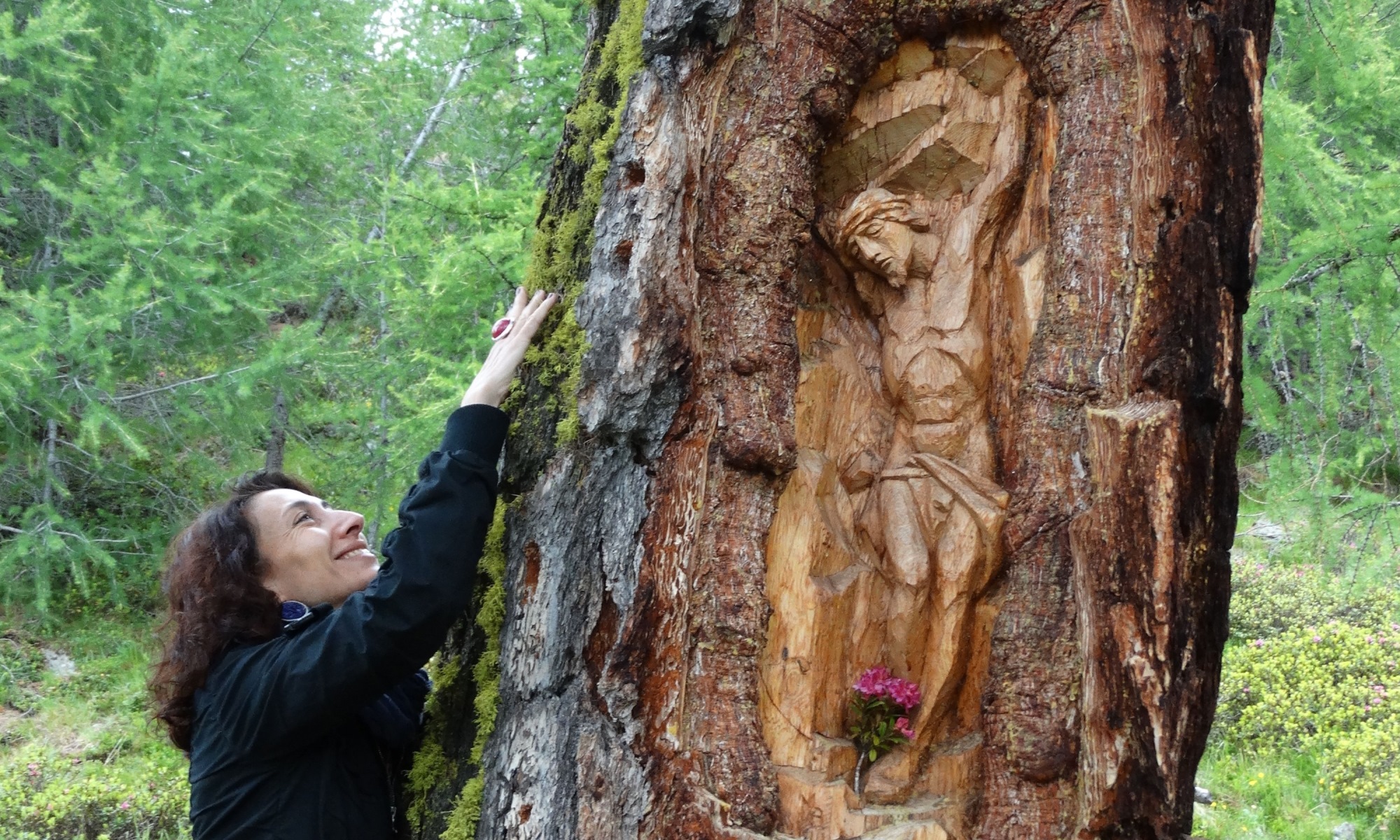
From the village of Ausservillgraten, the path leads across the Glinzbrücke on path 7 (forest path) in a northeasterly direction through dense spruce forest in a few bends to the Alten Hütte (1.740m). We continue on path 7a (forest path) through lighter larch forest to the Rautalm (1.882m) and on a very beautiful path to the Schupfalm (1.910m). On path 14b through species-rich flower meadows to the Wurzalm (2,001m). From here you have a wonderful view of the valley to Ausservillgraten and the surrounding mountains. From the Wurzalm the path leads slightly down into the Raucheggenbach. From there, a path leads along the tree line, through alpine roses and dwarf larches, over the Enziangrantl to the Kropfkaralm, on which there is a small shepherd's hut, and hike up to the Tilliachalm. This is where the hiking loop to the Sommerwandalm and Herrgottslärche begins. Follow the signs towards Gölbner and Sommerwand-Köpfl and climb up to a height of 2,350m. Now turn left and descend the path to the Herrgottslärche, this place is also a place of energy. Past the Herrgottslärche it goes to the Sommerwandalm and there descent to the Tilliachalm (2.030m). Descent to Reitersube possible here via forest path or climb. In front of the Reiterstube (1.500m) there is the Alm-Kneipp-Path Winkeltal on the right side.

Download:
Trump variant
- additional climb to Sommerwand-Köpfl auf 2500m
- moderate mountain tour - 9 hours walking time
- 18,9km walking distance
- 1410 ascent altitude
- 1170 descent altitude
- lowest point: 1.260m - Außervillgraten (Start)
- highest point: 2.500m - Sommerwand-Köpfl


Tourismusinformation Villgratental
+43 50 212 340
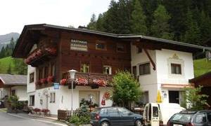
Gasthaus Perfler
+43 4843 5202
01.04.2025 - 26.10.2025
Mittwoch Ruhetag
Nur auf Vorbestellung
Übernachtung: ja
Jausenstation Reiterstube
+43 (0)4843 / 5188
im Juni Montags Ruhetag
ab Juli durchgehend geöffnet
12:00 - 19:00 Uhr
keine Übernachtungsmöglichkeit
The legend of the Giant Haunold
Closely connected to the mountain is the Pustertal legend of the giant Haunold. He was the son of a Roman commander who was killed in battle against the Huns.
Through a ruse, his wet nurse escaped with him to the farthest reaches of the Villgraten Valley, where a witch (the 'Lottermoidl') advised her to hide by a nearby spring. The water from this spring was miraculous, and Haunold grew up to be a giant. In the meantime, the Huns had built Heinfels Castle and ruled the Puster Valley terrifyingly. When Duke Tassilo arrived in the area and camped in St. Oswald, a delegation of peasants approached him with the request to end Hun rule. Duke Tassilo besieged the Hun castle but was unable to take it. The Hun prince was also unable to defeat the duke decisively, so the battle had to be decided in a duel. The Hun prince was so powerful, however, that no one wanted to oppose him. The duke sent a messenger to the Admirabus spring to ask the giant Haunold for assistance. At the confluence of the Sextnerbach and the Drau, a battle broke out between Haunold and the Hun prince. Haunold overcame the Hun and tore out one of his ribs, which now hangs above the gate of the San Candido Cathedral. In gratitude, Duke Tassilo founded the San Candido Monastery, in whose construction Haunold actively participated. The inhabitants of San Candido were less than pleased, as the giant had a huge appetite, so Haunold soon withdrew to become a hermit. Today, he sleeps in the mountain of the same name, waiting for the dawn of the promised time.
Historically, the founding of the Innichen Monastery by the Bavarian Duke Tassilo, as well as his journey through the Puster Valley, is correct. The tradition that Heinfels Castle was founded by the Huns or Avars is not confirmed by modern historical research. The rib in the Innichen Cathedral most likely came from a woolly rhinoceros.